18 April 2024
Update 26 July 2024:
Level Crossing Removal Project (LXRP) and the City of Glen Eira (Council) have reached an agreement to deliver the new on-road separated cycling lane on Queens Avenue.
The Copenhagen-style bicycle lane between Neerim Road and Normanby Avenue is the final section of path connecting Ormond to Caulfield Station and will provide a safe cycling connection for the local community. This final section of bicycle path meets a Victorian Government commitment to deliver the missing link in the area’s cycling corridor.
LXRP will fund construction as part of the Glen Huntly Level Crossing Removal Project, and Council will deliver the works on behalf of LXRP.
For more information please contact Glen Eira City Council.
We’ve removed the dangerous and congested level crossings at Neerim Road and Glen Huntly Road, by lowering the rail line into a trench. We’ve also built a new Glen Huntly Station.
As part of the Glen Huntly Level Crossing Removal Project, we’re also building a brand-new cycling path, meeting a Victorian Government commitment to deliver the missing link in the area’s cycling corridor.
The section of path between Neerim Road and Normanby Avenue is the final section connecting Ormond to Caulfield Station.
Improving cycling access in the area was identified by the community and key stakeholders as a core objective of the project, including delivering the most effective route.
For more than 2 years we have worked closely with Council to develop options for the active transport connection between Caulfield and Glen Huntly stations.
Until early January 2024, Council's preferred option was Queens Avenue. Council updated its position in the light of community concern about tree removal.
We've listened to community feedback and Glen Eira City Council's recommendation to develop a new design for Derby Crescent that retains vegetation and increases landscaping. This factsheet outlines all current designs under consideration that the community is being asked to provide feedback on, inclusive of previously consulted Queens Avenue options.
Options not under consideration
- Leamington Crescent shared use path
- Realign Queens Avenue (Glen Eira City Council proposal)
- Derby Crescent off-road. We will landscape along the east side of Derby Crescent regardless of where the cycling path ends up going.
Derby Crescent options
Derby Crescent is a local street that provides a safe option for an on-road cycling path. As part of a Derby Crescent design the vacant land between Lord Street and Neerim Road will be used as part a shared pedestrian and cycle path.
We have investigated two cycling path solutions for Derby Crescent – a separated path, commonly known as a Copenhagen-style solution, and an on-road design where all road users share the same space. The on-road option has fewer impacts to current conditions and would maintain the localised feel and character of Derby Crescent.
The on-road option is supported by traffic experts at the Department of Transport and Planning (DTP) and at Glen Eira City Council as a safe option. The on-road shared option would maintain the localised feel and character of Derby Crescent.
On-road Copenhagen-style solution
Overview of impacts
Tree removal | Road/traffic changes | Car parking removal | Increased vegetation opportunity | Separated cycling lane |
Minimal | Significant | Significant | No | Yes |
Tree removal
The Copenhagen-style design may require some trees to be removed because we may need to widen driveway access at the road, to allow enough space for vehicles to turn.
Road/traffic changes
Derby Crescent would become one way, and there would be traffic calming measures, such as speed humps and speed reduction signs.
Parking removal
Car parking removal along the rail side of Derby Crescent would be required as this space would be needed to form the separated cycling lane. Additional residential parking removal would also be required to allow turning for larger vehicles into driveways. Further residential parking may also need to be removed between Lord and Clifton streets as the road narrows and becomes too tight for parking, traffic and bicycles.
Separated cycling lane
A Copenhagen-style design provides a safe separated cycling lane that provides a physical barrier between cyclists and cars.
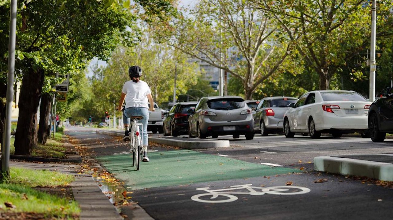
St Kilda Road Copenhagan-style bicycle lane example.
Shared on-road designs
There are three options for the Derby Crescent shared on-road design that we are asking the community to consider. Vehicles and cyclists would share the road. To make this option safe, we would slow traffic to make it safe, and discourage other vehicle users from using the street through a series of measures, such as:
Traffic calming – keeping the current vehicle access and roadway, with a combination of traffic calming measures such as speed limit signs, painted markings, speed humps, and raised road sections at T-intersections.
Traffic calming with road narrowings – allow only one vehicle to pass though at a time. This could mean some parking loss on the resident side as well as the rail side.
Traffic calming and closing Derby Crescent at Moodie St – cyclists could pass through the closure point but vehicles could not (known as a “modal filter”). Northbound vehicles would turn into Moodie Street and south-bound vehicle would enter and exit via Normanby Avenue and Epsom Street.
Overview of impacts
Tree removal | Road/traffic changes | Car parking removal | Increased vegetation opportunity | Separated cycling lane |
Minimal | Moderate | Minimal | Yes | No |
Tree removal
Minimal tree removal required except for a vehicle turnaround point if modal filter installed.
Road/traffic changes
To make it safe for cyclists and drivers to share the road, we need to slow down traffic. This would be done by using the measures noted above. This improves street access for cyclists and discourages non-residents from using the street as a shortcut. We have heard that residents are concerned about the speed of cyclists entering and exiting the Moodie St underpass. A pedestrian maze or similar will be installed at the underpass entrance to make a safe pathway for pedestrians by encouraging cyclists to dismount and walk their bikes through the underpass.
Parking removal
The extent of parking retained on the residential side of Derby Crescent varies dependent on the traffic calming measures chosen. All options would require some loss of parking on the rail side of Derby Crescent, however this also provides opportunities for further vegetation to be provided.
Increased vegetation opportunity
A modal filter potentially allows for further landscaping on Derby Crescent by planting in the traffic island and reallocating road space for new planting opportunities. We have heard that trees and vegetation are important to the local community.
We are looking at opportunities to increase tree canopy coverage along Derby Crescent. This could include installing “outstands” on the rail side of the road, planting where there was previously a car space. We have recently done this on Station Place, Glen Huntly working in partnership with residents and Council.
Shared use path
Any option for Derby Crescent would have a shared pedestrian and bicycle path along the vacant rail land between Neerim Road and Lord Street.
Queens Avenue
Options still under consideration
The 2 previously consulted options for a cycling path along Queens Avenue are still viable. These are an off-road shared path that would require the removal of 220 trees, and on-road separated cycling lane that would require the removal of residential side car parking.
We explored options presented to LXRP by Queens Avenue residents, including car parking in-set into the nature strip along the residential side of the road. This is not feasible because of the number of essential services that run under the nature strip and the large number of mature trees.
Off-road shared use path
A three-metre-wide off-road shared pedestrian and cycling path on the racecourse side of the road.
Overview of impacts
Tree removal | Road/traffic changes | Car parking removal | Increased vegetation opportunity | Separated cycling lane |
Minimal | Moderate | Minimal | Yes | No |
Tree removal
An off-road shared use path along Queens Avenue requires the removal of 220 trees. We will plant 90 trees.
Increased vegetation opportunity
We will plant 90 trees.
On-road Copenhagen-style solution
Overview of impacts
Tree removal | Road/traffic changes | Car parking removal | Increased vegetation opportunity | Separated cycling lane |
Minimal | Moderate | Significant | No | Yes |
Tree removal
Requires the removal of 20 trees.
Road/traffic changes
Speed reduced to 50km along Queens Avenue.
Parking removal
Requires removal of all parking along Queens Avenue.
Have your say
Council will be running a survey on the Derby Crescent options presented in this factsheet and sharing the results with LXRP.
Glen Eira Council will consult with the community regarding these options as it did in February for the Queens Avenue options. Council will consider your feedback before determining and communicating a preferred option to LXRP. The Council’s consultation will include information sessions and a survey.
Once this round of consultation is complete, we will develop detailed designs and share more information on the preferred option with you.
Cycling connection Project timeline
Community engagement on cycling path options
Late May 2024
Mid 2024
Path construction begins
Late 2024
Path construction complete
*Timeline subject to change
Landscaping and vegetation
Our landscaping plan for Derby Crescent allows for ground cover, understorey and small plants as well as up to 9 trees along the rail verge. We are working with Glen Eira City Council to explore increasing vegetation and screening on the rail side of the road. Landscaping on Derby Crescent has been on hold while the bike path route is finalised.
2 for 1 tree planting
We have committed to replanting 2 trees for every one that was removed during construction for the Glen Huntly Level Crossing Removal Project. As there is not enough space along the rail line to plant all these trees, we will plant over 500 trees within 1.5km of the Glen Huntly Station precinct.
We will landscape along the east side of Derby Crescent regardless of where the cycling path ends up going.
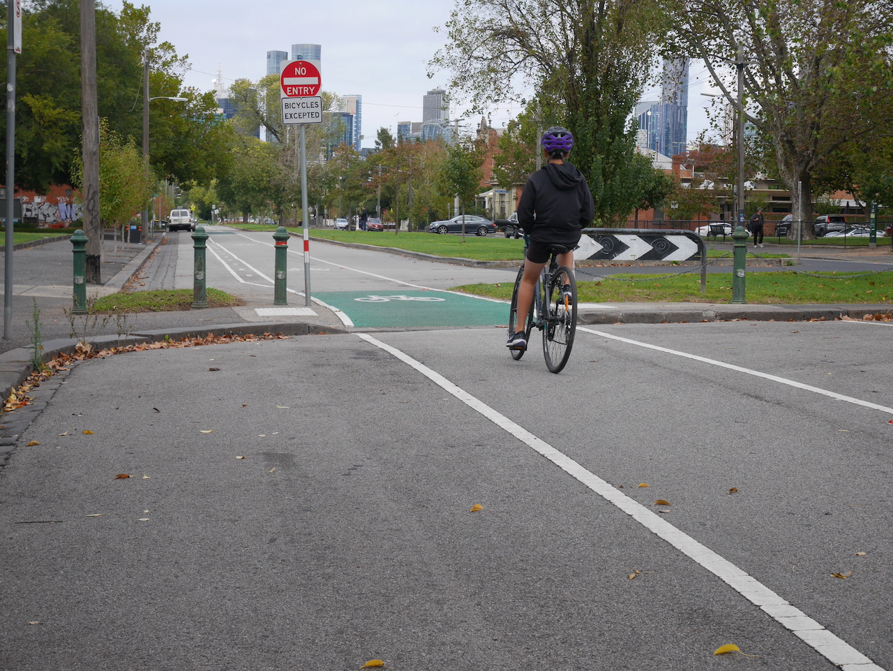
What is a modal filter?
A modal filter is a road design that restricts vehicle movement. It is used to help slow traffic on roads with low traffic. The filter can range from simple bollards to planted areas in the road.
Canning Street, Carlton North modal filter example.