27 October 2025
The Eastern Freeway Upgrades from Hoddle Street to Burke Road is committed to the protection of the Yarra River (Birrarung). One of the ways we are doing this is aligning our project design with the Yarra protection principles in the Yarra River Protection (Wilip-gin Birrarung murron) Act 2017.
About the Yarra River Protection Act
(Wilip-gin Birrarung murron) Act 2017
The Yarra River (Birrarung) is of great importance to Melbourne and Victoria. The Yarra River Protection Act recognises the intrinsic connection of the traditional owners to the Yarra River and its Country and further recognises them as the custodians of the land and waterway which they call Birrarung. The Act safeguards the Birrarung and its surrounding lands for future generations. It recognises the Birrarung and its environs as a single, living and integrated natural entity. It also aligns broader environmental and cultural goals, promoting sustainable development and community stewardship.
Part 2 of the Act outlines the Yarra protection principles that serve as the basis for planning, decisionmaking and management activities affecting the Yarra River and its environs. These principles are designed to ensure the river’s longterm health, cultural integrity and community value.
To read the full Yarra River Protection (Wilip-gin Birrarung murron) Act 2017, please visit www.legislation.vic.gov.au/ in-force/acts/yarra-river-protectionwilip- gin-birrarung-murronact- 2017/005.
| Yarra protection principle | Urban Design Landscape Plan alignment |
| General Principles | |
|---|---|
| (1) Proposed development and decision-making should be based on the effective integration of environmental, social and cultural considerations in order to improve public health and wellbeing and environmental benefit. | The design response has been collaboratively developed by a multidisciplinary, integrated Project team of urban and landscape designers, architects, engineers, planners and environment, heritage and sustainability specialists. Environmental, social and cultural considerations have been central to the collaborative design response, as follows:
|
| 2) Decision-makers should take into account the best practicably available information about the potential impacts of climate change so as to avoid, so far as possible, serious or irreversible damage resulting from climate change. | Environmental sustainability is embedded into the design response through an integrated design process that ensures sustainability requirements, targets, and opportunities are identified and incorporated across the North East Link Program. A Sustainability Design Brief is being used to communicate and develop the design response across the North East Link Program and includes sustainability targets and requirements relating to carbon reduction, life cycle impacts, Recycled First targets, integrated water management, resilience and ecology. Specific to this UDLP, potential impacts of climate change are addressed through the following:
|
| (3) Decision-makers should take into account the impact of any individual action or policy on public health and wellbeing and seek to ensure that public health and wellbeing is enhanced by the action or policy. | Public health and wellbeing are central to this UDLP, as follows:
|
| (4) Each generation should ensure that the environmental, social and cultural benefits that have been acquired are maintained or enhanced for the benefit of future generations. | This UDLP addresses the environmental, social and cultural benefits as follows:
|
| 5) Protection of the environment and delivery of sustainable development is a responsibility shared by all levels of government, industry, business, communities and the people of Victoria. | As outlined in Principle 2, the protection of environment and sustainability are considered at a broader level across the North East Link Program and through a Project-specific design response. The North East Link Program has gone through a rigorous Environment Effects Statement (EES) process, including the preparation and endorsement of an Environmental Management Framework (EMF) and Urban Design Strategy (UDS). This process has included involvement from all levels of government, industry, business, communities and the people of Victoria. |
| Environmental Principles | |
| (1) If there are threats of serious or irreversible environmental damage, lack of full scientific certainty should not be used as a reason for postponing measures to prevent environmental degradation or for failing to assess the risk-weighted consequences of the options. | The North East Link Program through the EES process has had regard to the precautionary principle and mindfully weighed up the impacts on the environment. The EMF endorsed by the Minister for Planning for the North East Link Program provides a transparent framework to manage environmental effects to meet statutory requirements, protect environmental values and sustain stakeholder confidence. The EMF includes Environmental Performance Requirements (EPRs), which are a suite of performance-based environmental standards and outcomes that apply to the design, construction and operation of the North East Link Program. |
|
(2) Environmental practices and procedures should ensure that biodiversity and ecological integrity is maintained or enhanced in ways that are proportionate to the significance of the environmental risks and consequences being addressed. | The Sustainability Design Brief used to communicate and develop the design response across the North East Link Program includes sustainability targets and requirements relating to ecology. The design response presented in the UDLP includes new landscaping in addition to the retention of existing significant vegetation and trees where feasible. New planting will include indigenous and native species of plants with the specific purpose of adding resilience to the habitat and biodiversity value of the corridor. This approach ensures sustainable use of resources in that species are robust for the current and future climate conditions and require minimal in terms of labour and water use for ongoing maintenance, once established. Additionally, areas where there is new or enhanced planting inherently provides more connected habitat links within the area, extending existing areas or filling in gaps where they exist. The EPRs protect biodiversity and ecological integrity, as follows:
|
| (3) If approaches to managing environmental impacts on one segment of the environment have potential impacts on another segment, the best practicable environmental outcome should be sought. | This UDLP adopts a holistic and integrated approach to environmental management. |
| (4) There should be a net gain for the environment in the area of Yarra River land arising out of any individual action or policy that has an environmental impact on Yarra River land. | The Project will provide a net gain for the environment in the area of Birrarung land through the following:
|
| Social Principles | |
| (1) The existing amenity of Yarra River land, including its natural features, character and appearance, should be protected and enhanced for the benefit of the whole community. | The existing amenity of the Birrarung (Yarra River) land is protected and enhanced for the benefit of the whole community through the following:
|
| (2) Community consultation and participation should play an essential and effective role in the protection, improvement and promotion of Yarra River land. | Community consultation for this UDLP prior to and after public exhibition includes:
The UDLP is available for public exhibition and comment for a period of 21 days from 27 October 2025. A Consultation Summary Report addressing written comments received during public exhibition and responses to issues raised will be provided to the Minister for Planning at the time of final UDLP submission. Following the Minister for Planning’s decision on this UDLP, the Project will report back to stakeholders and the community about how issues and opportunities raised through the public exhibition process were considered, including where changes were made to the UDLP. Engagement with stakeholders and the community will continue throughout the life of the Project to keep people informed of its progress and to ensure community and stakeholder priorities, concerns and opportunities are considered and responded to in a timely and transparent way. |
| Recreational Principles | |
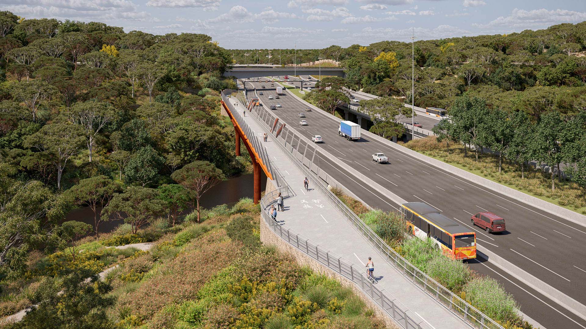
| (1) Community access to, and use and enjoyment of, Yarra River land should be protected and enhanced through the design and management of public open space for compatible multiple uses that optimise community benefit. | The provision of a new and upgraded SUP along the Eastern Freeway alignment will provide an efficient, safe and visually interesting active transport link. In particular, the provision of a SUP crossing of the Birrarung, as well as under Chandler Highway and Burke Road, will provide substantial benefits by improving walking and cycling connectivity to and through Yarra River parklands and the Main Yarra Trail. New built elements on Birrarung (Yarra River) land, while respectful and fitting to place, are memorable and distinctive. For instance, the SUP bridge is a unique crossing of the Birrarung (Yarra River), delivering an engaging experience for pedestrians and cyclists. It is also a distinctive wayfinding event and a vibrant element along the journey. Further west of the SUP bridge is Yarra Bend Park, where secondary paths at the existing River Circuit Trail and enhancements to public open space have been incorporated into the design to provide enhanced safety, function and enjoyment. |
| 2) Public open space should be used for recreational and community purposes that are within the capacity >of that space, in order to sustain natural processes and not diminish the potential of that open space to meet the long-term aspirations of the community | The importance and prominence of public open space is integral to the design response proposed through this UDLP. The SUP through Yarra Bend Park, including the SUP bridge, improves access to public open space and provides a new route for walkers and cyclists through this culturally significant park. Upgrades to the existing River Circuit Trail at Fairlea Reserve will further contribute to the enhanced function of public open space at the interface with the Project. The proposed SUP also provides enhanced access to public open space east of Yarra Bend Park, including new connections to the Main Yarra Trail east of Chandler Highway. Where the proposed freeway infrastructure and SUP adjoins key destinations for active and passive recreation, such as at Kew Golf Club, retaining walls have been provided to minimise encroachment into this area. Elsewhere within the Project retaining walls have also been utilised to minimise the extent of battering. |
| Cultural Principles | |
| (1) Aboriginal cultural values, heritage and knowledge of Yarra River land should be acknowledged,reflected, protected and promoted. | The design narrative has been developed following endorsement from WWCHAC to explore appropriate cultural themes and will be refined through a careful and collaborative co-design process that is ongoing. The design is guided by the cultural perspective of Waa, the Crow, one of the two moiety ancestors in Wurundjeri Woiwurrung cosmology. Waa the Crow and Bunjil the Wedge-tailed Eagle and creator spirit are both significant figures for Victorian Aboriginal communities. Whilst Bunjil flew over a formless Country creating land, waterways and its people, Waa as his helper held responsibility as protector of Wurundjeri Woi-wurrung people. The design process has involved a rigorous and respectful investigation of the landscape to identify sites with inherent physical and cultural significance. Working alongside WWCHAC representatives, including cultural knowledge holders, the codesign process has sought to understand the underlying characteristics that may have influenced patterns of use and cultural practice: geology and soils, the presence of particular species, seasonal flows of water, views to the sky (and its constellations at night), and topographic forms that may have offered shelter, gathering space, or acoustic qualities for ceremony. Through this process, a series of sites within the Project area will be identified as places where cultural stories and practices may be meaningfully expressed or evoked. The sites for co-design interventions will be carefully chosen due to their inherent qualities to share and provide experiences that will prompt the user to understand Wurundjeri Woi-wurrung physical and spiritual connections to Country and how they may have interacted with these places. Subject to ongoing WWCHAC co-design process, it is anticipated that the agreedupon sites will host a range of design intervention responses. These may range from subtle to immersive, or iconic, and are intended to reveal previously unseen or unspoken aspects of Country identified as of importance to both this site and the broader Wurundjeri Woi-wurrung Country context. |
| (2) The role of the traditional owners as custodians of Yarra River land should be acknowledged through partnership, representation and involvement in policy planning and decision-making. | A co-design process is being undertaken with the WWCHAC in parallel with the preparation of the UDLP. The Project will be working with the WWCHAC to further develop meaningful and innovative ways to represent Indigenous cultural themes and living culture into the design. |
| (3) The cultural diversity and heritage of post-European settlement communities should be recognised and protected as a valued contribution to the identity, amenity and use of Yarra River land. | Post-European settlement historical elements along the freeway have been retained in the design response. For example, the historic gate pillar adjacent to the Westfield Grasslands at Yarra Bend Road will be a formalised point of interest along the SUP, along with strategic tree planting and access to encourage pedestrian interaction. All but three of the existing iconic mast light poles on the Eastern Freeway west of Chandler Highway are retained and converted to LED as required, supporting wayfinding and efficient lighting for motorists along the corridor. Necessary additions to existing bridges are geometrically sympathetic to the structures, maintain sightlines and views and minimise visual impacts. New structures adjacent to the existing bridges are complementary in form and placement. The landscape strategy recognises and exemplifies the existing tree planting design unique to this corridor, maintaining and enhancing the tree-lined setting of the Eastern Freeway. |
| Management Principles | |
| (1) There should be coordination between all levels of government and government agencies when designing policies and programs and making decisions in relation to Yarra River land. | Key Victorian Government stakeholders consulted in the development of this UDLP include Department of Transport and Planning, Melbourne Water, Heritage Victoria, Parks Victoria, Department of Energy, Environment and Climate Action and the Office of the Victorian Government Architect. Key local government stakeholders consulted included representatives from Boroondara and Yarra Councils. |
| (2) When designing policies and programs, the best practicable measures available at the time should be used. | This UDLP incorporates best practicable measures to implement the UDS, meet EPRs and provide an enduring legacy from the Project. |
| (3) Implementation of natural resource management should aim for continuous improvement and extend beyond compliance with relevant laws and requirements. | The design response has been developed in accordance with the approved UDS, which requires that the design of the North East Link Program is of high quality and beyond compliance in order to achieve superior outcomes. |
1800 105 105 (call anytime). For languages other than English please call 9209 0147.
If you need assistance due to a hearing or speech impairment, please visit relayservice.gov.au