11 March 2025
The below notice refers to the temporary closure of roads from time to time to facilitate works on the Webster Street, Dandenong Level Crossing Removal Project under section 186D(1)(d) of the Major Transport Projects Facilitation Act 2009.
For more information about specific disruptions in the area, please refer to the latest works notice and disruption information on the Webster Street, Dandenong level crossing project page.
Major Transport Projects Facilitation Act 2009
(Section 186D(1)(d))
NOTICE OF CLOSURE OF PART OF ROAD TO TRAFFIC
Under section 186D(1)(d) of the Major Transport Projects Facilitation Act 2009 (Act), I, Andrew Pepplinkhouse, Program Director, North Wester, Level Crossing Removal Project (LXRP), as delegate of the project authority for the Webster Street, Dandenong Level Crossing Removal Project (Project), determine that, for the purposes of the Project, the following roads and parts of roads (as applicable) shall be closed to traffic:
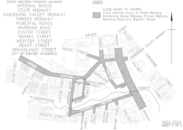
- Part of Cheltenham Road, Dandenong from the Hammond Road intersection to the Foster Street intersection;
- Part of Thomas Street, Dandenong from Foster Street intersection to Lonsdale Street intersection;
- Webster Street, Dandenong;
- Part of Lonsdale Street Dandenong from Webster Street intersection to Foster Street intersection;
- Part of Lonsdale Street Dandenong service lane from Thomas Street intersection to Foster Street intersection;
- Part of Hammond Road Dandenong from Dalgety Street intersection to Cheltenham Road intersection;
- Part of Cheltenham Road Dandenong from George Street intersection to Hammond Road intersection;
- Part of Lonsdale Street Dandenong from Foster Street intersection to Pultney Street;
- Part of Foster Street Dandenong from Cheltenham Road intersection to Pultney Street intersection;
- Part of Thomas Street Dandenong from Foster Street intersection to Gilbert Lane intersection;
- Part of Bryants Road Dandenong from Webster Street intersection to approximately 50 meters south;
- Part of William Avenue Dandenong from Webster Street intersection to approximately 50 meters south;
- Part of Ellis Street Dandenong from Webster Street intersection to approximately 50 meters south;
- Part of Raymond Street Dandenong from Webster Street intersection to approximately 50 meters south;
- Part of Lonsdale Street Dandenong from Webster Street intersection to approximately 100 meters south;
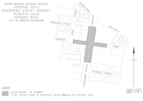
- Part of Frankston-Dandenong Road Dandenong from approximately 130 meters south of Kirkham Road intersection to approximately 100 meters north of Kirkham Road intersection;
- Part of Kirkham Road Dandenong from John Street intersection to approximately 75 meters east of Frankston-Dandenong Road intersection;
- Heart Street, Dandenong;
- Broadland Street Dandenong; and
- The laneway between Heart Street and Hammond Road,
as more particularly shown cross hatched on the attached plan.
The closure of the parts of roads identified on the plans shall commence on the later of 1 March 2025 or one day after the date on which this notice is published.


Andrew Pepplinkhouse
Program Director, North Western, LXRP and delegate of the Secretary to the Department of Transport and Planning under the Act.