11 May 2022
We’re fixing the missing link between the M80 Ring Road and an upgraded Eastern Freeway – reducing travel times by up to 35 minutes and taking 15,000 trucks off local roads a day.
We’ve listened to what people had to say through the Environment Effects Statement (EES) process. In late 2021 we released a project design with longer 6.5km tunnels to Watsonia, simpler interchanges and 50 MCGs of open space across the entire North East Link Program.
We also appointed Spark, a team of some of the best builders in Australia and around the world, to build the North East Link Tunnels from Watsonia to Bulleen.
Before we get major construction underway, we’re exhibiting an Urban Design and Landscape Plan to ask the community what they think of the look and feel of what’s planned for their area. This includes new parklands, wetlands, bike and walking paths and improvements to local roads.
North East Link near you
- 6.5km longer tunnel
- 2km boulevard for Greensborough Road
- 5 MCGs of community parklands
- 3.4km of walking and cycling paths
- 1,950+ new trees planted
The North East Link Tunnels will take traffic and trucks under instead of through our suburbs and give local roads back to local people.
Longer tunnels and a simpler Lower Plenty Road interchange have created more space for new parklands, better walking and cycling paths and to change Greensborough Road into a tree-lined boulevard.
See the map on the fact sheet for more details.
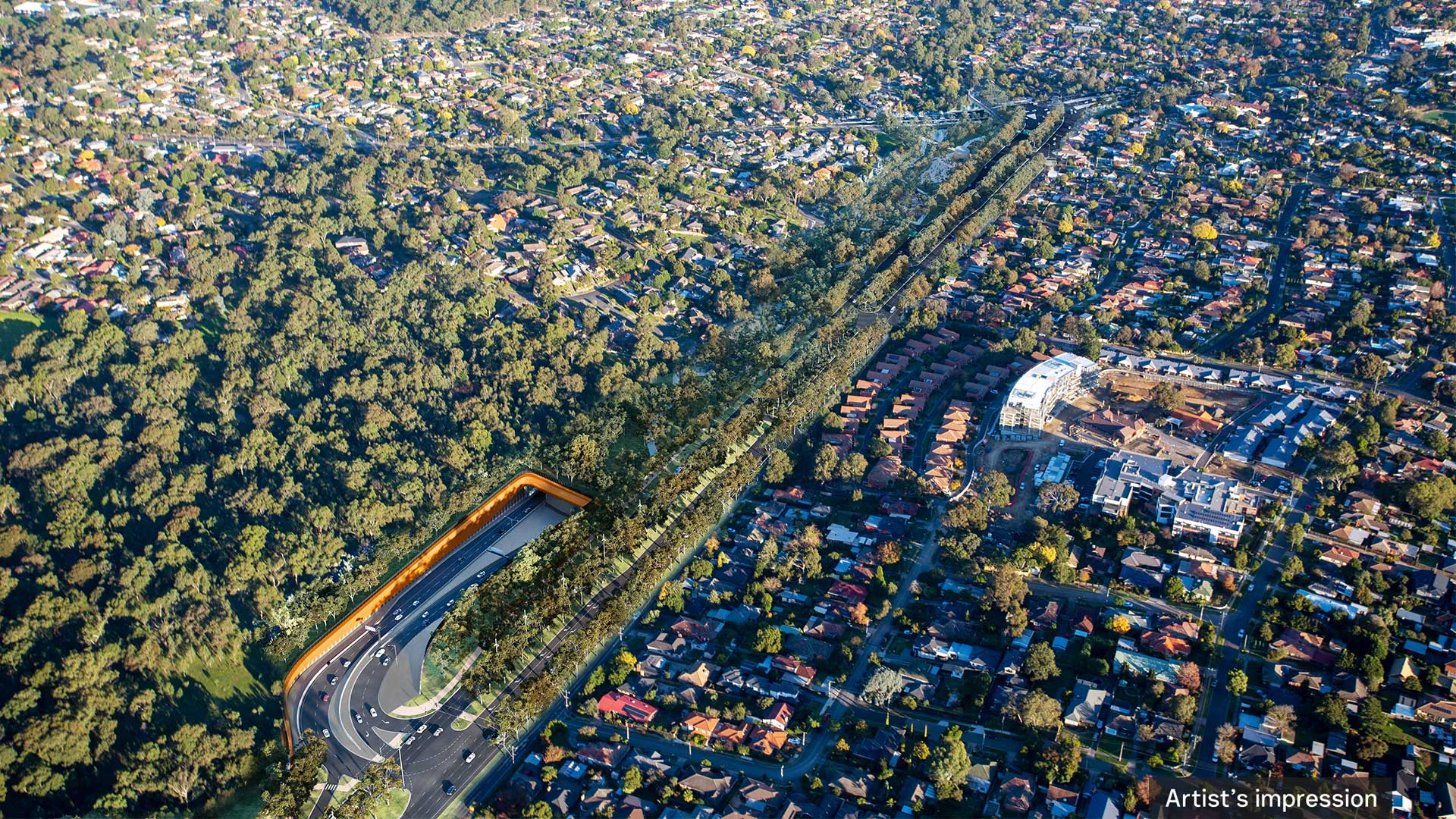
Longer North East Link Tunnels
In response to community feedback we’ve extended the North East Link Tunnels to Watsonia by tunnelling an extra 1.9km using tunnel boring machines (TBMs) – keeping more works underground.
Simpler Lower Plenty Road interchange
If you live in the local area and want to use North East Link it’s now easier. Ramps in Watsonia will connect you to the M80 Ring Road. Ramps in Yallambie will connect you to the Eastern Freeway.
Greensborough Road boulevard
With less trucks and congestion, Greensborough Road will be a better road for local trips and to live on. We’re using space created by the longer tunnels to:
- rebuild 2km as a tree-lined boulevard with avenues of eucalyptus trees and a 10m wide median
- create a new, 5m wide service road for safer and easier access to homes, more space for walking and cycling paths and on-street parking for residents and visitors.
We’re also delivering the better east-west access people asked for with:
- upgraded intersections at Erskine Road and Yallambie Road
- new intersections at Finlayson Street and Fairlie Avenue/Blamey Road
- an extra lane in each direction to reduce queuing at lights.
6 new and upgraded intersections and crossings will make Greensborough Road safer and easier to use.
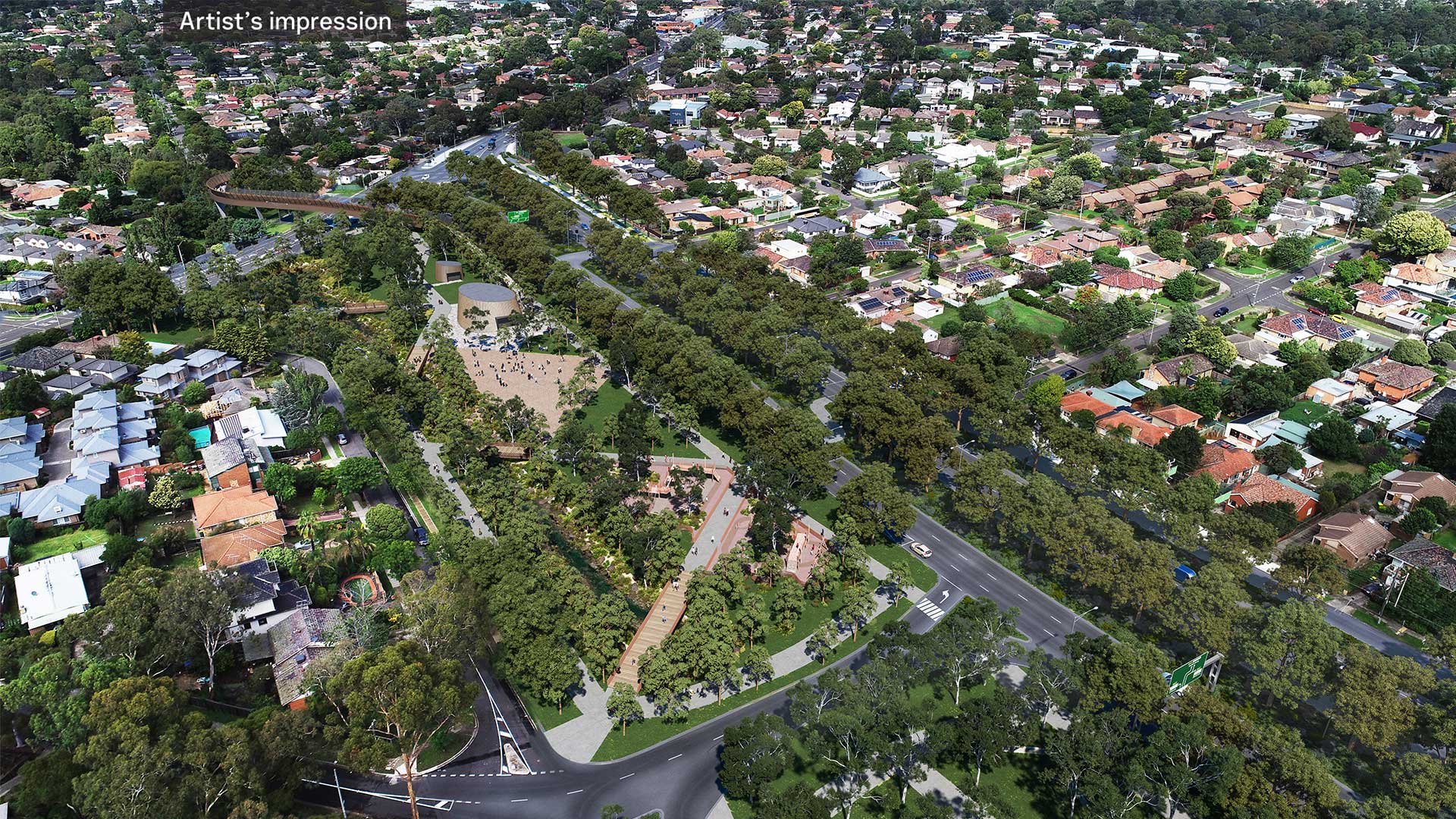
Borlase Reserve parklands
The simpler Lower Plenty Road interchange has created 5 MCGs of new parklands along Banyule Creek, including a major expansion of Borlase Reserve to the north with space to:
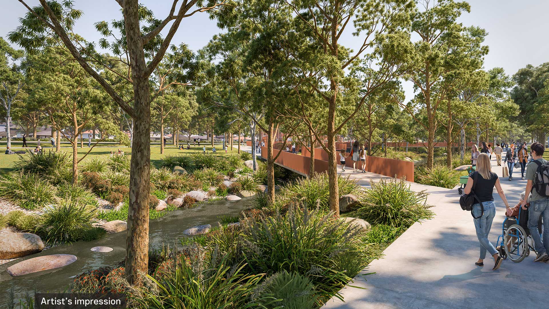
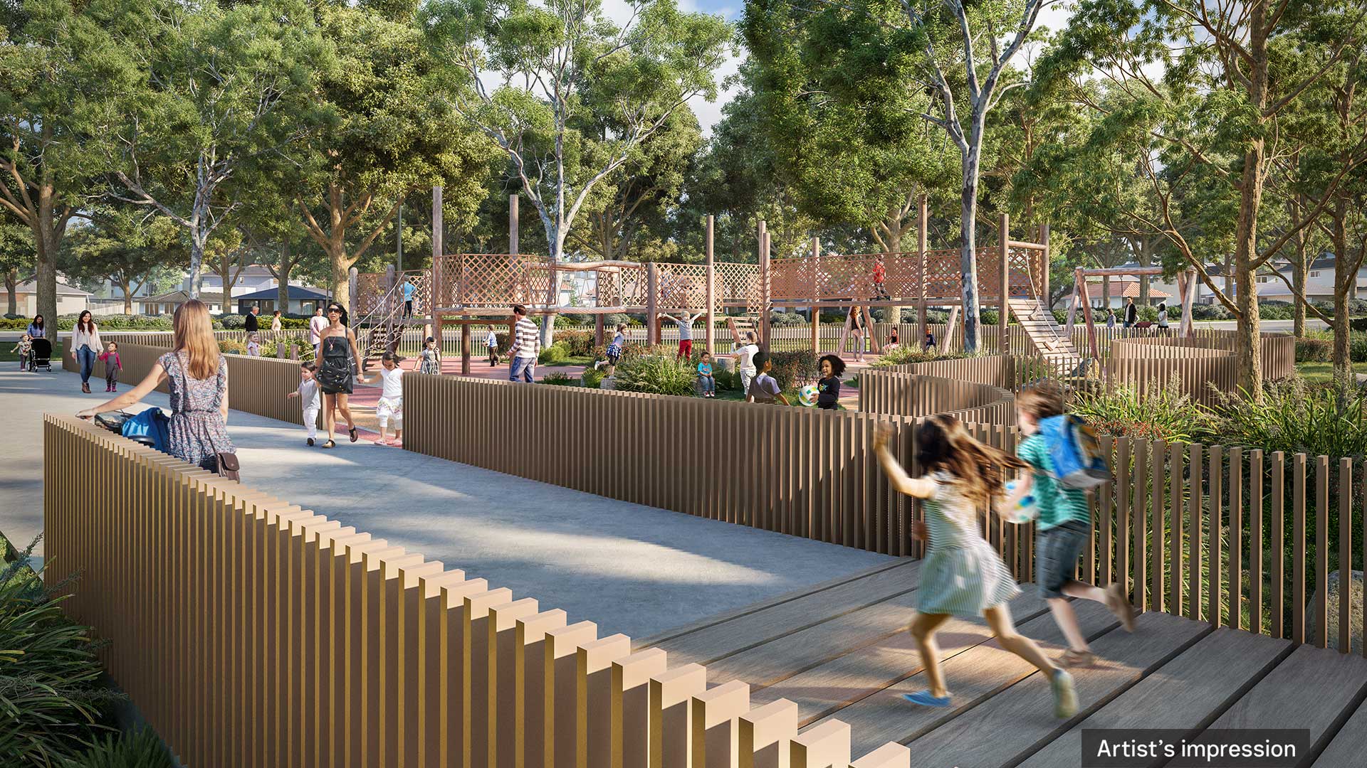
- revitalise 1.2km of Banyule Creek as a nature and habitat corridor with wetlands, paths and boardwalks
- build pockets of new open space, a nature playground, BBQ areas, a half basketball court, drinking fountains, public toilets, bicycle parking and seats
- plant more than 100 different species of indigenous trees, grasses, shrubs and flowers, including from seeds collected in the local area.
Tunnel ventilation structure
The design for the ventilation structure has been inspired by traditional Wurundjeri eel traps and surrounded by new trees and plants. Solar panels on the sides will help power the tunnels below.
North East Trail
The North East Trail through Watsonia, Macleod, Yallambie and Rosanna will deliver 3.4km of new and upgraded walking and cycling paths including:
- a new bridge over Lower Plenty Road to Banyule Flats and Yarra River parklands designed to represent an iuk (eel) swimming in a river
- wide, shady paths along both sides of Greensborough Road with 4 fitness stations
- 6 signalised Greensborough Road crossings including at Moorwatha Street through to Macleod Station
- a 2.2km on-road cycle lane on Greensborough Road for faster commuter trips to Watsonia Station.
Tree planting program
To build the North East Link Tunnels, trees will need to be removed while we’re working at the surface. This will help make space to launch and operate the tunnel boring machines, build the Lower Plenty Road interchange and the new Greensborough Road boulevard.
For every tree removed, at least 2 will be planted including extensive planting along the new Greensborough Road boulevard, at the new Borlase Reserve parklands and to revitalise Banyule Creek where land used for construction will be returned to the local community.
- 1,950+ new trees will be planted for the North East Link Tunnels in Watsonia, Macleod, Yallambie and Rosanna
Building Victoria’s longest road tunnels
While we’re refining the design through the Urban Design and Landscape Plan (UDLP), you’ll see us out and about getting ready for major tunnelling works to begin later this year.
This will involve:
- geotechnical investigations and site surveys
- setting up construction compounds
- beginning to prepare the tunnel boring machine (TBM) launch area in Watsonia
- beginning to prepare the Lower Plenty Road interchange area in Yallambie.
Designing the tunnel alignment
We’re working on the best route for the tunnel boring machines to take beneath the Yarra River and parklands and will be out talking to residents who will have the tunnel near them later this year.
Key dates
Early 2022
- site investigations and surveys
Mid 2022
- construction compounds established
- work to prepare the TBM launch area begins
Late 2022
- work to prepare Lower Plenty Road interchange begins
2024
- tunnel boring begins
2028
- North East Link opens to traffic
Visit our website for more information about works in your area and to sign up for regular updates.
Help shape designs for your local area
The Urban Design and Landscape Plan for the North East Link Tunnels is on exhibition now.
The UDLP has detailed maps and drawings of the project design and an explanation of how it meets strict requirements in place for North East Link.
Making a submission is your opportunity to have a say on local elements for your area including new parklands, wetlands, walking and cycling paths and improvements to local roads.
We’ll be using what we hear to finalise the UDLP before submitting it to the Minister for Planning later this year for approval and getting major construction underway.
Where to see the plan
You can find out more about the UDLP and see a copy online from Wednesday 11 May to Tuesday 31 May 2022 at Engage Victoria or visit a display and talk with our team at:
Watsonia Community Information Hub
- Visit during our regular opening hours, or drop in this May on a Thursday night or Saturday.
- Monday to Friday, 10am to 5pm (10am to 7pm Thursdays)
- Saturday, 10am to 2pm
Veneto Club
- Saturday 14 May, 21 May and 28 May, 10am to 2pm
You can also view the UDLP at local council offices and libraries. To find a location near you visit Engage Victoria.
How to make a submission
Make your submission online at Engage Victoria by 5pm, Tuesday 31 May 2022.
If you need help accessing the UDLP, or to make a submission, please contact us on 1800 105 105 or at community@northeastlink.vic.gov.au
This information is current at the time of publication, however changes may occur. Please visit our website for the latest updates.