1 August 2022
The Fyans Street and Surf Coast Highway level crossings are being removed and replaced with elevated rail as part of the South Geelong to Waurn Ponds Duplication project. Removing these level crossings will improve safety and traffic flow, allow more trains to run, and create new cycling and walking connections.
As part of planning the project, a robust options assessment was undertaken to determine the most feasible design solution for each of the level crossing locations.
Both sites are complex with many environmental, community and technical considerations to be understood and balanced. An elevated rail bridge has been identified as the most feasible design solution at both locations to reduce disruption to road and rail users during construction, minimise flooding risks and create opportunities for landscaping and green open space. Below is an overview of the key considerations used to determine the design solution.

Environmental and location considerations
Environmental and topographical factors such as underground water levels, ground conditions and nearby sensitive waterways were considered. Protecting nearby waterways from contamination and reducing flooding events is critical to a sustainable design solution.
There is an existing floodplain within the project area at both Fyans Street and Surf Coast Highway, and a high-water table at Fyans Street. Elevating the rail line reduces the risk of future flood events impacting train services at both locations.
An elevated rail bridge at Fyans Street also avoids interrupting the flow of storm water as well as reduces the risk of contamination to the Barwon River or Waurn Ponds Creek catchments.
Construction considerations
The amount of disruption during construction will vary depending on the design option selected and proposed designs aim to minimise these impacts as much as possible.
A trench solution involves the excavation and removal of a significant amount of soil which would increase the number of trucks and equipment required during construction. An elevated rail option is quicker to build, and at Fyans Street will halve the rail line closure time needed for construction resulting in less disruptions to passengers and residents.
Improving traffic network safety and efficiency
We assess the impact each design option may have on existing roads, and walking and cycling paths. The selected designs improve traffic flow around the local area and minimise disruptions to local traffic during construction.
A trench option would increase impacts to the local road network during construction as Surf Coast Highway and Fyans Street would be closed for almost all of the construction period. An elevated rail design ensures access can be maintained for vehicles, cyclists and pedestrians, resulting in less disruption during construction.
Future proofing design
Future proofing means considering future transport network requirements and allowing for future projects which will be built after the project is completed.
An elevated rail design allows for greater integration with future projects including the Bellarine Link ring road extension.
Design standard compliance
There are a number of principles and design requirements which the project must adhere to. These include national and state level standards from VicRoads Department of Transport, V/Line and local council.
An elevated rail design meets all of the design standards the project must adhere to.
Local amenity improvements
The potential to create new green open space and enhance the surrounding landscape is a key consideration.
Elevated rail bridges create an opportunity for tree planting, landscaping and urban design treatments to enhance the local area.
At Surf Coast Highway the elevated rail bridge will shift the rail line up to 90 metres away from local residents, creating the opportunity for new green open space and new cycling and pedestrian paths.
The chosen design
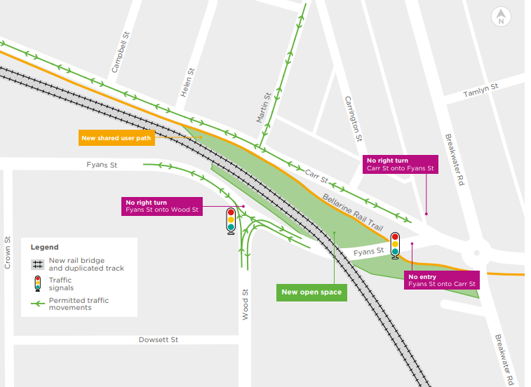
An elevated rail bridge is the most feasible design solution at both locations. It will maximise opportunities to add green space along the rail line as well as offer better connectivity and safer paths for pedestrians and cyclists. High quality urban design and landscaping treatments will be built into the designs to ensure they integrate with the existing character of the area.
The elevated rail solution will:
- provide a safer intersection for all road users
- enhance the local area and streetscape through landscaping and architectural elements
- minimise disruption during construction with less road and rail shutdowns
- be delivered faster
- better integrate with future transport infrastructure projects such as the Bellarine Link ring road
- enable new shared user path connections between South Geelong and Waurn Ponds
- enhance the local area and streetscape through landscaping and architectural elements
Other options
A trench option would significantly increase impacts to the local community during construction, is more difficult to build due to the floodplain and high water table at Fyans Street, and would also reduce the reliability of the Geelong line in the future due to flooding risks.
Other options were not selected due to:
- more rail closures, meaning more disruptions for passengers and the community
- more environmental impacts due to high level of soil excavation
- greater traffic impacts and road closures during construction
- high groundwater levels increasing the risk of contamination to nearby sensitive waterways
- existing floodplain at both locations increasing the risk of flooding and impacting rail services
- extending the construction timeframe and delivery of the project
- more environmental impacts due to high level of soil excavation