between Plenty and Yan Yean roads
with existing bridge becoming a pedestrian bridge
for walking and cycling
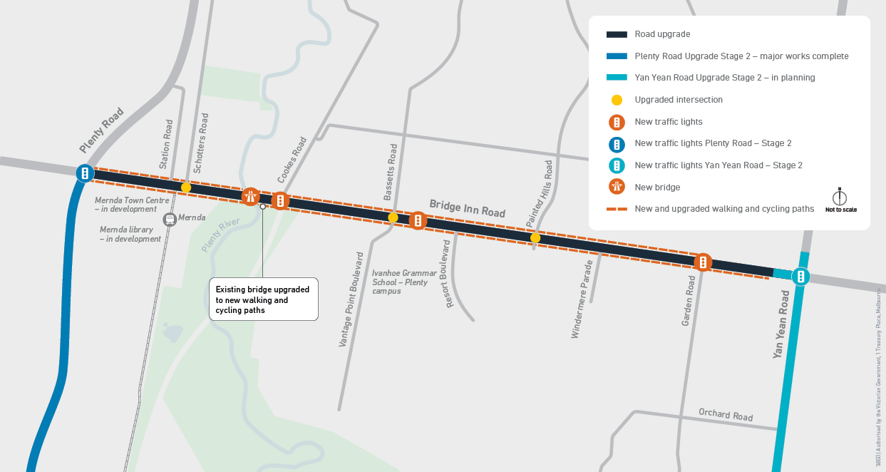
As part of the Bridge Inn Road Upgrade, we also:
- installed traffic lights at Cookes Road and Garden Road
- installed a dedicated signalised pedestrian crossing near Ivanhoe Grammar School
- upgraded the intersections at Schotters Road, Vantage Point Boulevard and Painted Hills Road
- installed safety barriers along the road.
This upgrade has improved traffic flow and safety, provided better access to Mernda train station and town centre and made it easier and safer to walk and cycle in the local area.
Project map
Timeline
Major construction for this upgrade was completed in October 2024.
Explore the project
Video: project overview
An overview of the Bridge inn Road Upgrade
Audio: Repetitive music playing.
Visual: Aerial view of the Bridge Inn Road Upgrade.
Text: Bridge Inn road Upgrade.
Visual: Aerial view of the intersection of Bridge inn Road and Plenty Road.
Text: Intersection of Plenty road and Bridge Inn Road recently upgraded.
Text: Extra lanes in each direction. Six lanes to Plenty River.
Text: Better connections to residential developments and jobs.
Visual: Aerial view showing location of Mernda Town Centre and Mernda Train Station.
Text: Entry to the new Mernda Town Centre.
Visual: Aerial view showing location of the intersection of Bridge Inn Road and Schotters Road.
Text: Extra lanes at the Bridge Inn Road and Schotters Road intersection.
Text: Better access to Mernda train station.
Visual: Aerial view showing location of the walking and cycling path.
Text: Relocation walking and cycling path to Plenty Gorge.
Text: Two lanes in each direction from Plenty River to Garden Road.
Visual: Aerial view showing location of Plenty River, Plenty Gorge Parklands, the new bridge over Plenty River and the old bridge to be turned into a pedestrian bridge.
Text: New bridge over Plenty River for cars and trucks.
Text: Improved traffic flow and safety.
Text: Existing historic bluestone bridge will be turned into a pedestrian bridge.
Text: Better walking connections.
Visual: Aerial view of intersection of Bridge Inn Road and Cookes Road.
Text: Upgraded intersection with new traffic lights.
Visual: Aerial view of Bridge Inn Road showing new walking and cycling path locations.
Text: New walking and cycling paths.
Text: Easier and safer to walk or cycle in the area.
Visual: Aerial view of Bridge Inn Road.
Text: New safety barriers along length of Bridge Inn Road.
Text: Lower the risk and severity of crashes.
Visual: Aerial view of intersection of Bridge Inn Road, Bassets Road and Vantage Point Boulevard showing location of upgraded intersection with extra lanes.
Text: Improved traffic flow and safety.
Visual: Aerial view of Bridge Inn Road showing location of new traffic lights and pedestrian crossing near Ivanhoe Grammar School.
Text: Improved access to local schools.
Visual: Aerial view of Bridge Inn Road intersection with Painted Hills Road and Independence Boulevard.
Text: Upgraded intersection with extra lanes.
Text: Improved traffic flow and safety.
Visual: Aerial view of Bridge Inn Road showing extra lanes and centre barriers and walking and cycling paths.
Text: Extra lanes along Bridge Inn Road. Centre barriers and walking and cycling paths.
Visual: Aerial view of intersection of Bridge Inn Road and Garden Road.
Text: Upgraded intersection with new traffic lights.
Text: Easier and safer access in and out of Bridge Inn Road.
Visual: Aerial view of Bridge Inn Road showing the location of the eastern boundary of the upgrade.
Visual: Yellow background.
Text: Building Better Roads.
Visual: Black background.
Text: Major Road Projects Victoria. Victoria’s Big Build. Victoria State Government. Australian Government.